Field Trip
Exploring Active Faults in the Constantine Basin
Overview
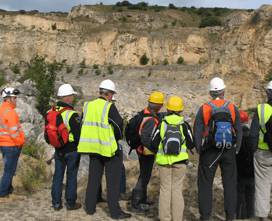
Join us for a one-day field trip on October 29, 2025, as part of the International Symposium on Seismic Risk, Urbanization, and Resilience in the Western Mediterranean (SURE-MED), marking the 40th anniversary of the 1985 Ms6.0 Constantine earthquake. This excursion explores active fault systems and associated geohazards in the Constantine Basin, northeastern Algeria. Designed for students, researchers, and professionals, the trip offers hands-on insights into seismic hazards, regional tectonics, and their implications for urban resilience. Participants will also visit the ancient Roman city of Tiddis, bridging modern geoscience with historical adaptations to the region’s dynamic geology.
Geological Context
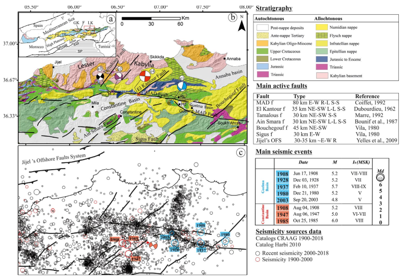
The Constantine Basin, a Neogene east-west intramontane basin, is located on the southern margin of the Lesser Kabylia block within the Tell Atlas thrust belt of northeastern Algeria. Formed after the main Tell thrusting event in the Lower Miocene, it evolved in a continental setting with lagoonal and lacustrine phases since the Middle Miocene, accumulating reddish conglomerates, grey gypsum marls, and lacustrine limestones. Its complex neotectonic history, driven by successive episodes of transtension and transpression, has shaped a morphotectonic framework ideal for active tectonic studies. The basin experiences frequent moderate seismic activity, concentrated primarily along its borders, which are defined by active faults exhibiting a predominantly strike-slip regime, as evidenced by geological records (slickenlines), seismotectonic data (focal mechanisms), and geodetic measurements.
Northern Boundary: North Constantine Fault
The northern boundary of the Constantine Basin is defined by one of the most prominent strike-slip faults in North Africa, the North Constantine Fault (also known as the Mcid Aicha Debbagh Fault). This over 100-km-long east-west fault zone, part of the 300-km-long Ghardimaou—North Constantine (GNC) fault system, delineates the northern margin of the Constantine and Guelma pull-apart basins, separating them from the Numidian Chain. The fault system accommodates approximately 2.4 mm/yr of convergence between the African and Eurasian plates and generates frequent moderate seismicity (M<5), including the 2017 Mw 4.7 sequence along its central segment. Although no major historical earthquakes are directly linked to this fault, geological and morphotectonic evidence suggests significant seismic potential. The fault’s intersection with the Beni Haroun Dam, Algeria’s largest, highlights its societal and economic importance. Segmented by NE-SW and NW-SE transverse faults, the system has produced moderate events, such as the 2020 Mw 4.8 Mila sequence.
Southern Boundary: El Aria and Ain Smara Faults
The southern boundary of the Constantine Basin, unlike the northern boundary, is not defined by a single major fault but by a system of neotectonic NE-SW-oriented faults, including the El Aria Fault and the Ain Smara Fault system. The El Aria Fault was responsible for the 1985 Ms 6.0 Constantine earthquake. Although these faults are less prominent in seismotectonic records, they are critical to the region’s seismotectonic framework. The Ain Smara Fault, a 20-km-long western segment of the El Aria system, borders the Djebel Felten-Sekkoum-Sellem massif. While inactive during the 1985 earthquake, its fault scarps and deformed Quaternary deposits indicate recent activity, suggesting a significant seismic risk to the Constantine region.
Additional Hazards: Landslides
The Constantine Basin’s steep topography, combined with climatic and lithologic factors, makes it highly susceptible to landslides, which are often triggered by seismic activity or anthropogenic activities. These hazards are among the most challenging in the region, as their contributing factors interact across regional scales. The 2020 Mw 5.0 Mila earthquake triggered catastrophic landslides, highlighting secondary geohazards that pose significant challenges to urban development
Field Trip Highlights
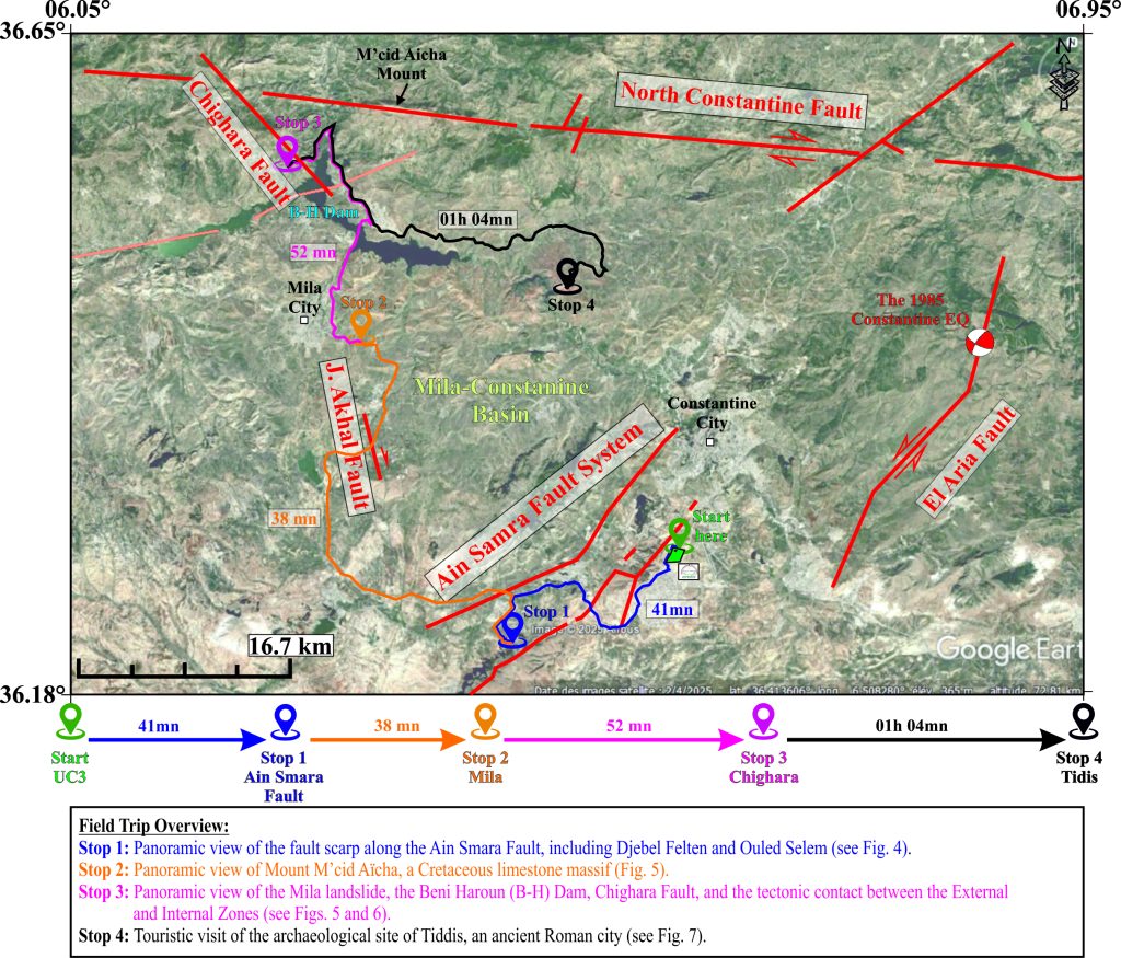
This field trip provides a hands-on exploration of the Constantine Basin’s tectonics and geohazards, with four key stops:
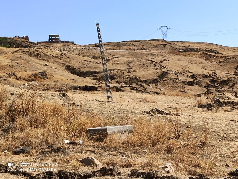
- Stop 1: Ain Smara Fault (4 km from symposium venue): Observe a N40E-striking fault scarp, visible in satellite imagery and field, and examine geomorphic evidences underscoring the fault’s activity.
- Stop 2: El Kharba Landslide (Mila): Panoramic view on the 2020 coseismic landslide site to analyze the interplay of tectonics, topography, and lithology in triggering mass movements, a critical factor for urban planning (Hallal et al., 2024) (Figs. 1 and 5).
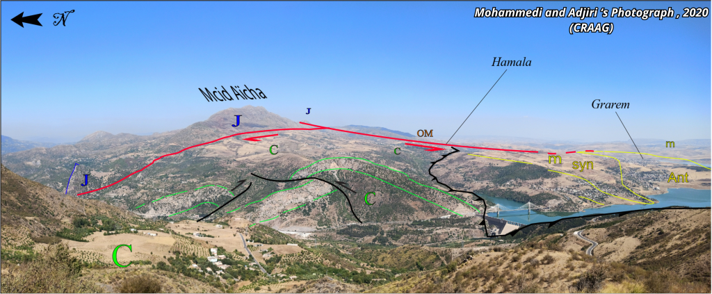
- Stop 3: Mcid Aicha Debbagh Fault: Study morphological evidence of active faulting and discuss its role in regional convergence, its proximity to the Beni Haroun Dam, and implications for seismic risk (Bendjama et al., 2021) (Figs. 1 and 6).
- Stop 4: 2020 (Mw 4.8) Hamala Mainshock: Panoramic view of Mount M’cid Aïcha, a Cretaceous limestone massif (Figs. 1 and 5)
Stop 5: Tiddis Archaeological Site: Explore the Roman-Berber city of Tiddis, offering a panoramic view of the basin and insights into historical adaptations to its dynamic geology, connecting geoscience with cultural heritage (Figs. 1 and 7).
Field Trip Details:
- Date: October 29, 2025
- Duration: Approximately 8 hours
- Prerequisites: Background in geoscience or related fields recommended. participants).
- Equipment: Comfortable clothing, sturdy footwear, notebook, and optional camera.
- Capacity: Limited to 50 participants (registration required).
- Logistics: Transportation and meals provided.
References
Note: The following references are a selection of key studies relevant to the Constantine Basin’s geology, seismotectonics, and geohazards. This list is not exhaustive, as the region has been extensively studied in additional works not cited here.
Aris, Y., Coiffait, P. E., & Guiraud, M. (1998). Characterisation of Mesozoic–Cenozoic deformations and palaeostress fields in the Central Constantinois, northeast Algeria. Tectonophysics, 290(1–2), 59–85. https://doi.org/10.1016/S0040-1951(98)00012-2
Bendjama, H., Yelles-Chaouche, A., Boulahia, O., Abacha, I., Mohammedi, Y., Beldjoudi, H., Rahmani, S. T.-E., & Belheouane, O. (2021). The March 2017 earthquake sequence along the E-W-trending Mcid Aïcha-Debbagh Fault, northeast Algeria. Geosciences Journal, 25(5), 697–713. https://doi.org/10.1007/s12303-020-0059-y.
Bougrine, A., Yelles-Chaouche, A. K., & Calais, E. (2019). Active deformation in Algeria from continuous GPS measurements. Geophysical Journal International, 217, 572–588.
Bounif, A., Haessler, H., & Meghraoui, M. (1987). The Constantine (northeast Algeria) earthquake of October 27, 1985: Surface ruptures and aftershock study. Earth and Planetary Science Letters, 85(4), 451–460. https://doi.org/10.1016/0012-821X(87)90140-3
Hallal, N., Hamidatou, M., Hamai, L., Aguemoune, S., & Lamali, A. (2024). Landslides triggered by the August 2020 Mw 5.0 Mila, Algeria, earthquake: Spatial distribution and susceptibility mapping. Euro-Mediterranean Journal for Environmental Integration, 9(3), 1063–1085. https://doi.org/10.1007/s41207-024-00471-w
Harbi, A., Maouche, S., & Ayadi, A. (1999). Neotectonics and associate seismicity in the Eastern Tellian Atlas of Algeria. Journal of Seismology, 3(1), 95–104. https://doi.org/10.1023/A:1009743404491
Maouche, S., Abtout, A., Merabet, N.-E., Aïfa, T., Lamali, A., Bouyahiaoui, B., Bougchiche, S., & Ayache, M. (2013). Tectonic and hydrothermal activities in Debagh, Guelma Basin (Algeria). Journal of Geological Research, 2013, 1–13. https://doi.org/10.1155/2013/409475
Marmi, R., & Guiraud, R. (2006). End Cretaceous to recent polyphased compressive tectonics along the “Môle Constantinois” and foreland (NE Algeria). Journal of African Earth Sciences, 45(1), 123–136. https://doi.org/10.1016/j.jafrearsci.2006.01.009
Meghraoui, M. (1988). Géologie des zones sismiques du Nord de l’Algérie: Paléosismologie, tectonique active et synthèse sismotectonique [Doctoral dissertation]. Université de Paris-Sud, Centre d’Orsay.
Mohammedi, Y., Djellit, H., Yelles-Chaouche, A., Hamidatou, M., & Hallal, N. (2019). New evidence of active faulting along the Ain Smara Fault in the Constantine Province (North East Algeria). In Recent Advances in Geo-Environmental Engineering, Geomechanics and Geotechnics, and Geohazards (pp. 271–273). Springer. https://doi.org/10.1007/978-3-030-01455-1_59
Mohammedi, Y., Yelles-Chaouche, A., & Adjiri, S. (2021). The Mila 2020 seismic sequence in north-eastern Algeria: Seismotectonic context and geohazard consequences. Mediterranean Geosciences Union (MedGU), 25–28 November 2021.
Raoult, J.-F. (1975). Évolution paléogéographique et structurale de la chaîne alpine entre le golfe de Skikda et Constantine (Algérie orientale). Bulletin de la Société Géologique de France, S7-XVII(3), 394–409. https://doi.org/10.2113/gssgfbull.S7-XVII.3.394
Vila J.M., 1980. La chaîne alpine d’Algérie τrientale et des confins algéro-tunisiens. Thèse de Doctorat, Université P. et M. Curie-Paris.